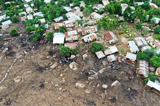
Malawi is experiencing severe floods and mudslides following Tropical Cyclone Freddy. GLOBHE provides aerial data to UNICEF Malawi to monitor vulnerable areas and create impact-based flood risk maps. These maps enable the organization to provide anticipatory and predictive scenarios to avoid human suffering and infrastructure damage etc.
RELATED: MTN: Digital technologies can act as important enabler to address climate change
“Due to climate change, we see more destructive climate disasters more frequently worldwide. Malawi has suffered from three major floods in the past four years. Data from drones help respond to floods more efficiently but also help limit the destruction in the first place. However, it’s been hard to get ahold of data from drones, and we’re happy to have changed that by unleashing the power of drones through the Globhe marketplace – now making data from drones easily accessible when and where it’s needed,” says Helena Samsioe, Founder and CEO at Globhe.
From Planes to Drones in a few clicks
Globhe recently signed a long-term agreement with UNICEF Malawi to provide drone services in emergency preparedness and response. The platform connects over 8000 local drone operators with stakeholders in need of data collection in 134 countries. It is the leading drone data marketplace for collecting aerial imagery and generating digital terrain models to support flood modeling. Globhe’s clients, such as UNICEF Malawi, can order drone data missions from the Globhe drone data marketplace with just a few clicks.
“Using high-end drones to capture this critical data is very effective, both in terms of getting accurate and high-resolution data as well as reducing the carbon footprint of the monitoring operations,” says Margherita Bruscolini, Head of Drones at Globhe
More Detailed Than Satellites
The teams from Globhe have captured data from 6200 Ha in Rumphi and 13500 Ha in Karonga in Malawi. The project was executed by local drone operators and surveyors, most of whom have graduated from the African Drone Data Academy, an initiative supported by UNICEF.
Using ground control points (GCPs), Globhe captures highly accurate data, connecting the models produced with known coordinates on the ground, giving it a high vertical and horizontal accuracy of around 10 cm. The spatial resolution is significantly higher than satellites, which generally produce a 5-30 meter resolution, compared to the 5-centimeter resolution for the Orthomosaic maps and 50 centimeters for Digital Surface and Digital Terrain models.
“Our drone data give a better representation of reality and terrain features, and this level of accuracy is key to doing correct flood risk modeling and enabling an effective preparedness and disaster response,” says Alexander DC Mtambo, Head of Drones Africa at Globhe.
Recent mudslides and floods in South Malawi are a reminder of how important the work is. Using drones to create flood models will significantly improve disaster management capabilities and give the country a better chance of protecting the communities from the devastating effects of floods.
“Our work with preventive flood mapping plays a key part in mitigating risks to humans and infrastructure, and therefore there is a great need to continue the preventive efforts in Malawi going forward,” says Alexander DC Mtambo, Head of Drones Africa at Globhe.


